Pages

Thursday 18 October 2012

19th century Norwich Flickrs into life

Norwich, Colman's mustard factory on the River Wensum, late 19th century

IMAGINE you’re a county council with a fantastic archive of old photos. You’ve got a great online search system but you still feel you could reach a wider audience. What do you do? Well if you’re Picture Norfolk you dip a toe in the wonderful world of Flickr and see what happens.

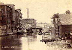
This photo shows the River Wensum just downstream of Carrow Bridge with Colman’s factories dominating the left bank. And it’s one of 36 photos that Picture Norfolk have published on Flickr within the last couple of months. One of the problems with being so open of course is that bloggers like me come along and cheekily republish. Hey, come on guys, I’m a huge fan and it’s a huge plug too.

So let’s take a closer look at this late 19th century scene. First that’s the old Carrow Bridge some distance downstream from the current one. It was originally directly opposite Carrow Hill and ran directly through Colman’s factories. Hence the mustard company was keen to reposition both road and bridge. The replacement – which survives to this day - was opened in 1923.

That’s a wherry of course moored next to Colman’s. I’m no expert but it looks pretty high in the water. Waiting to be loaded with goods to be sent down to Yarmouth perhaps? My money’s on the wherryman having a crafty pint at one of the dozens of boozers which lay along neighbouring King Street at this time. The boatsheds on the right bank are a surprise to me. Would these have been for boatbuilders or for more recreational use? Help if you can.

And finally I’m guessing that the tall chimney would have belonged to the riverside brewery firm Youngs, Crawshay and Youngs. Their operation was on the site of the modern Wensum Lodge.

* For more pictures of Norfolk check out Picture Norfolk’s other flickr photos here. or do it the old school way here.

Saturday 29 September 2012

New Mills: should it stay or go?

P7300172

Here’s a first draft for my entry for this strange old building built across the Wensum. Famous these days for being the head of navigation for the river, the site oozes history. But what should happen now?

(Incidentally in plain English the head of navigation means the highest point on a river that boats can safely sail/motor to.)

Here goes:       

“The building on the New Mills site today is neither new, nor a mill, nor even plural come to think of it. But over the centuries, mills new and old have harnessed the power of the Wensum here and they’ve played a surprisingly pivotal role in Norwich’s history. Their very existence prompted a major uprising in the 15th century, while high bread prices provoked a good old-fashioned food riot in the 18th century.

The date of the first mill is lost in antiquity. One could well have existed before the Norman Conquest. We think the “New” refers to mills built in about 1430 when they were used to grind corn. These buildings were at the centre of a major row between the city fathers and the church authorities: the church (then - as now - a major landowner) claiming that the mill affected the flow of the river upstream at Heigham.

Relations between church and city were troublesome throughout this period, but it’s still surprising to learn that mill buildings could provoke what historians call “Gladman’s Insurrection” in 1443. As many as 3,000 people effectively besieged Norwich’s cathedral close, threatening to burn the priory and kill the monks. A noble called Gladman was alleged to have imitated the king, prompting accusations of treason. Ultimately the real king had to get involved and it was four years before the city was finally forgiven.

By the 16th century New Mills was also being used as a source of drinking water, with supplies being pumped towards the city centre. Private houses could now pay to have water on tap – even if the quality would still be seriously questionable for centuries. By the 17th century more formal “waterworks” are mentioned while it was clear that the power of the water was still being used to help fullers to clean cloth and millers to grind corn.

Then in 1766 the New Mills was besieged by a mob wanting fairer prices for bread. This food riot was one of a number to erupt across the country at this time. The mill itself seems to have survived but a large malthouse was set on fire.

P8020203

The 19th century saw increasing concern over the quality of the water entering the works. With untold factories and privvies upstream, the New Mills were fighting an unequal battle and it was no surprise when a new waterworks was built at Heigham – a good mile upstream where the water was considerably cleaner. The last miller left a few years later and the mill buildings were finally pulled down in 1893. What we see there now is a Victorian pneumatic ejection sewage pump put out of its misery in 1973, together with some still-useful sluices.

So what should we do it now? True, the only other such sewage pump is to be found at the Houses of Parliament (insert your own metaphor here). But in reality New Mills is a modest building on an unattractive bridge without a hope of finding a useful purpose in life. So, future museum to Victorian engineering or blot on the landscape? I have to confess, I can’t quite decide.”

Saturday 15 September 2012

The River Tud: primary sources

Sept 15th 089

YOU know you’ve got this book-writing bug bad when it’s a sunny September Saturday and you’re really looking forward to searching for the source of the River Tud.

Sandwiched between the Wensum to the north and the Yare to the south, the Tud pretty much shadows the A47 east from Dereham, winding through places like Hockering, Honingham, Easton and Costessey before flowing into the Wensum at Hellesdon Mill.  (Strangely it runs between East Tuddenham and North Tuddenham without running through either, but that’s another story.) I make it just short of 15 miles from one end to the other.

Clearly all this should be well beyond the boundaries of a book called Riverside Norwich, but since virtually nothing is written about the Tud, I reckon it’s well worth a page of “biography”. That and the fact that I am enough of a river anorak to quite enjoy the thrill of the chase.

So where to start? Well the map shows the thin blue line running out at Spurn Farm on the southern fringes of Dereham. And the only way to find out more is to head west and knock on the farmhouse door.

It’s only recently that I’ve realised that this sort of thing scares the living daylights out of a lot of people. But I’m a newspaper journalist by trade and I love it. It reminds me of working on my first weekly up in the Yorkshire Dales. Go in with a smile on your face and you’ll always get a story, they told me. And they were pretty much right. These days - and with this book - I find proffering an Ordnance Survey map goes a long way too.

Anyway I was greeted by two black labradors and retired farmer Sue Haney …who quickly assured me that yes, I was in the right place. She was kind enough to take me down to a modest enough channel of water, one end of which is known as “the little watering hole” (pictured). 

It’s not a spring, it’s not pretty, it’s not dramatic and Sue talks of other field drains coming in from other directions too. But yes her family, who have farmed here for three generations, see it as a (she was quite insistent on “a” not “the”) source of the River Tud.

But “a”,on a farm with a history going back at least 200 years, is plenty good enough for me. Another page gets written, another photo gets taken, another minor mystery is solved. So, on a summer Saturday, thanks very much Sue.

* More on the Tud from February 2011.

Friday 14 September 2012

Drayton Rd factory: mystery solved

Shoe factory via Stu McP gr

THEY’RE a clever lot on the Norfolk Broads Forum. Earlier this week I asked what the strange objects were on this photo showing the old Edwards & Holmes shoe factory on Drayton Road. The answer? Animal skins.

Read these comments posted on the NBF website and you can almost smell them drying in the breeze. Stale urine baths? Nice.

“Being outside a shoe factory, my guess would be animal skins being prepared, perhaps oiled to make them waterproof. The racking at the back looks like it is a drier.Tanned leather is usually a pasty grey white colour before it is dyed ready for production.”          

Dylly

“Could well be 'greenhides' drying. We used  to have a proper tannery in Canterbury (and boy did it stink) and the hides after the basic tanning are a slightly greenish tinged cream colour. (we used to buy the rejects up at £10 a hide for making leather stuff for re-enactment). The tanning was done the proper way using oak galls and stale urine baths, and proper messy it was too.”

Grendel

“Totally agree with the previous posters. In the late 60’s I used to work in the east end of London. In the road that I worked there was a traditional tannery, I think it was called Braybrooks. On a summers day the smell was overpowering and boy the liquid that ran out into the road (no pavement or proper drains) used to rot the bottom of your car out while you watched. None the less it was a fascinating process to watch although doing it looked hard work.”

Still-Cruising

Wednesday 12 September 2012

After the Finishers finished

Shoe factory via Stu McP

THIS view across the Wensum in the northern suburbs of Norwich might shock anyone who’s moved in over the last decade or so. It shows the old Edwards & Holmes shoe factory on Drayton Road, once a big employer, now long gone.

In its place (just upstream of Wensum Park) is a new housing development featuring streets with names like Clickers Road and Finishers Road. Both are terms, you’ll be glad to hear, that mean something to the average cobbler. A Clicker cut the leather for the uppers of shoes using a machine which made, you guessed it, a clicking sound. Finishers water-proofed, blackened and waxed the shoe at the end of the production line.

Edwards and Holmes was clearly a big factory, but I have no idea what the long light-coloured objects are at the water’s edge. Something to do with rowing or something to do with the shoe industry? Give us a shout if you know the answer.

* Thanks to StuMcP for his help on this one.

Wensum Hell to Half 1011 129

Saturday 1 September 2012

Heigham: a text from the 1920s

scan0001

EBAY has come up trumps again. This photo shows a loop of the Wensum around what is now the Heigham waterworks. Except that in 1922 the works had yet to be visible along this stretch at least. (If I’ve got it right we’re looking east, so it’s Hellesdon on the left and Heigham on the right. Do let me know if you disagree.)

As ever when you go back in time, it takes a while to tune into the different lingo. Put an ebay search out for “Norwich” and “Wensum” for example and you wouldn’t have found this one. In those days it was simply “The Back River” as opposed I guess, to the busy commercial Yare.

And you won’t find “Horse Shoe Bend” on any modern map either. It’s only a reference to Horse Shoe Reach on a 1767 map in the Norfolk Record Office that means I can be sure I know what I’m looking at. Mind you its horseshoe shape is clear enough on the modern OS Explorer map.

The other thing that initially bugged me about these postcards was who on earth would go on holiday and send this sort of card to friends? But again it was because I hadn’t tuned into the times properly.

scan0004

Read the other side and you realise that these were quick missives scribbled out in much the same way as we would text or email. “Shall be back on Monday by bus if the roads are slippery. If not shall drive from Rugby” is the straightforward message on this one.

It is of course rather bizarre to be eavesdropping on a conversation 90 years on. But thanks to the late Mrs F Basson of Appendix Road, Rugby, another small piece of my book has fallen into place.

Sunday 13 May 2012

Boudicca Way: part two

Boudicca 2 008

JUST a few miles west from the wide, flat Yare Valley, lies the tighter, narrower vale of the River Tas. The rolling countryside here feels very different: as though you’ve crossed a county border rather than just a small watershed. I was picking up where I left off last August, taking the Boudicca Way footpath off Caistor Lane and heading towards Chandler Road across typically High Ash Farm country: broad grassy field edges planted with wildlife-friendly flowers. Then, climbing up Valley Farm Lane, you look back at field upon field of  rape. (pictured above).

Confusingly, at the junction of Valley Farm Lane and Chandler Road, the Boudicca Way signs point in both directions. Turn left and you’re on the  proper route south to Shotesham, right takes you on a diversion to the wonderful Roman remains at Caistor St Edmund. Boudicca 2 108

I turned right for a simple circular, but  spent a good hour exploring the environs of the old Venta Icenorum first. I haven’t been here for years and I’d forgotten quite how close the old walls are to the River Tas – although of course that’s the reason the Romans settled here in the first place. Many a family trooped around the walls, sheep grazed alongside and a wheatear perched obligingly on a fence post. Does a separate Tas Valley walk head into the distance along the left bank of this photo (right)? I leave that one for another time.

From there it’s a quick walk down to the Caistor Hall Hotel and then up Caistor Lane along some more wildlife- and pedestrian-friendly fields full of dancing orange-tip butterflies. The hum of the southern bypass never quite leaves you on this walk. But in some ways that’s part of the attraction. So much countryside, so close to the city and some socking great Roman remains into the bargain. I just wonder what the ghost of Boudicca makes of her walk heading into the enemy’s HQ.

Boudicca 2 115

Friday 27 April 2012

Oak Street: follow that wall

032

THIS picture is all about why the grass isn’t growing down that middle strip. It’s because the flints are actually the remains of the once substantial City Wall, built around Norwich in the middle ages. The wall once continued across the road and ran down to the river beyond Oak Street. The house directly opposite used to be The Dun Cow pub which directly abutted the wall. Its owner was kind enough to show me a great chunk of it in his basement today.

025

And this second photo is the best I can do of the remains of the round tower behind the old pub along an alley which still leads down to the river. From what remains, it seems that this was where the wall ended – although if it did, it would have left a good 50 yards undefended. Someone will have written a full history of Norwich City Walls. I need to track that down. It’s early days on the research, but Oak Street feels like a real victim of the inner ring road to me. Clearly it used to be a busy thoroughfare into the city. But it’s been cut in half and lost a bit of its soul as a result.

Incidentally what am I going to call this chapter? We’re talking about the east side of the river Wensum, so it includes Mile Cross, St Martins and Oak Street, but I can’t think of a handy all-encompassing title.

There’s no shortage of material. I’ve done the Mile Cross estate and Wensum Park and now it’s time to get my head round the little-known Great Hall and the old shoe factory once run by Sexton, Son and Everard. But first, I need to follow that wall.

Thursday 26 April 2012

WW2 Norwich: every tag tells a story

NRO 4
LET me introduce you to the Norwich Bomb Map, an amazing piece of Second World War history with a big story to tell. It’s fully six-foot square, a yellowing chart set within a wooden frame showing the greater Norwich area in quite some detail. But it’s not the map itself which is important, it’s what’s on it. Because during the war it hung in the city council’s planning department in Ber Street. And every time a bomb went off, the location was recorded on a tiny tag which gave the weight of the explosive in kilogrammes and then the date. To my knowledge, even 70 years after the Baedeker raids, it remains the best geographical representation of the impact the war had on Norwich. At a glance you can see which parts were most affected, at a glance it pretty much confirmed my theory that the Heigham area of the city was particularly badly-hit.
NRO 0412 002
For years this gem lay all but forgotten in the basement of City Hall. But these days it’s being much more carefully looked after by specialist staff at the Norfolk Record Office. You can get to see it, but only if you make an appointment a few days in advance. I did that last Friday and was guided through the building’s state of the art facilities to a conservation studio where the map had been wheeled out specially for me. There, senior conservator Nick Sellwood explained the problems  his team face when it comes to ensuring the map’s survival:
“The pins are ferrous, so they’re rusting,” he told me. “The cardboard tags are likely to be of pretty poor quality because most stuff was during the war and if you look closely you can see how dirty the map itself is – we’ve experimented a bit by just cleaning up the odd field on the outskirts. You can see they’re a lot lighter.
“Now we could change the pins, we could change the map, we could replace just about everything, but then it would no longer be what it is, so we’ve got this massive ethical dilemma about what to do with it.”
NRO 0412 008
The other irony is that the more people want to look at the map, the more fragile it will become – even with much TLC from the NRO. Among the possible answers, detailed photos which could be accessed via the web. My mind immediately raced ahead to an online digital map where you could click onto a tag which could be cross-referenced to other surviving documents together with contemporary and modern photos. (Nick Stone and his Blitz Ghosts would love that wouldn’t he?) But in the current financial climate I suspect such an idea would be way too ambitious. So for now let’s appreciate what we’ve got. A complete overview of the Norwich as targeted by the Luftwaffe.
* A big thank you to Nick Sellwood for a great insight into the world of the conservator …and 1940s Norwich. Thanks also to the County Archivist of Norfolk for permission to reproduce the photos of the map. And for the record, the map is from the Norfolk Record Office, ACC 2007/195. Click on the individual maps to bring them up full-frame.

NRO 2

Thursday 5 April 2012

Where was the Waterworks Tavern?

Heigham 0211 070THE SUBURB of Heigham is dominated by something we see hardly anything of – the waterworks along the road of the same name. Ok, there are these lovely old buildings at the city end, but the rest of this huge site is surrounded by high walls and fences. A manager from Anglian Water was kind enough to give me a guided tour earlier this week and I’m now getting my head around a mass of info. The tallest of these buildings for example, is the Chamberlain constructed in 1906 to house a huge beam engine. The rest of the site shows evidence of the water industry at every stage from 1850 to the present day. Why 1850? Because that was when the City of Norwich Waterworks Company was set up in a response to a deadly cholera epidemic. Drinking water in Norwich before that date appears to have been only slightly better than playing Russian roulette.

But the reason for my post is an appeal for info on the pub which all of the waterworks’ staff would have regarded as their local. It was called The Waterworks Tavern and it was apparently right next to the works on Heigham Street. But where exactly? And does anyone have a photo? Apparently it didn’t close until 1975 so someone, somewhere, surely?

* Please email sanddsilk@btinternet.com if you have any info or photos.

Friday 30 March 2012

Ancient rivers, modern pipes

P8030250

SO how many rivers are there in Norwich? The Wensum of course and the Yare too. Those in the know might add the Tud at Costessey and the Tas near Lakenham. But how about the Dalymond and the Dallingfleet, the Great and the Little Cockey and the Muspole? These too were once well-known names to Norwich citizens. To a greater or lesser extent they still exist today. But hidden beneath concrete and contained within culverts they are Norwich’s secret rivers. Archaeologist Brian Ayers is the expert. Most of what I’ve written here relies on his book “Norwich: Archaeology of a Fine City”.

The Muspole ran into the north bank of the Wensum from small pool of the same name near the modern Muspole Street. Water from the Great Cockey still emerges from a pipe (main picture above, canoe-view of course) near the Art College having flowed through the city centre from the high ground near All Saints Green. The Little Cockey ran from Chapelfield down to the river at Westwick Street.

OLYMPUS DIGITAL CAMERADownstream, the Dalymond rose in Old Catton and entered the Wensum off Fishergate at Hansard Lane. Again its outfall into the Wensum can only be seen by canoe (left). Lastly the Dallingfleet ran into the Wensum between the grounds of the cathedral and Foundry Bridge.

Friday 23 March 2012

Utopia in a Norwich car park

Utopia

WHEN Rory Macbeth started this artwork in 2006, the bricks and mortar which formed his canvas were due to demolished the following year. But six years later the old Eastern Electricity building is still standing. And so if you do find yourself wanting to read the entire text of Thomas More’s 16th century work Utopia without resorting to the library, just wander down to the car park off Westwick Street. At the time of the contemporary art exhibition, Macbeth said he’d done it because the work was “as valid now as it was when it was written”. An online article written at the time by Sarah Morley continued:

“Utopia is 100 pages long, so Rory worked out precisely where each line must be positioned for the entire 40,000 words to fit on the wall.

J bridge 041

“I like expressing the text through graffiti,” he explained, “as most graffiti is utopian – the world would be perfect if this or that were different.”

The building, visible from across the river, is due to be demolished in about a year’s time, so there won’t be any need to wash the graffiti off if anyone objects to Rory’s style of art. On the contrary, he has had lots of positive support: “We’ve made lots of friends, everybody wants to know what we’re doing.”

How much longer can it survive I wonder?

Thursday 22 March 2012

The Jarrold: playing hard to get

J bridge 015 cr

SO how on earth do you get a decent photo of the new Jarrold Bridge across the Wensum then? It’s not that I don’t like this sinuous j-shaped structure, even the designer rust grows on you after a while.  It’s just that when you get your camera out, it fails to look enough like a bridge, which ever angle you tackle it from.

Bridge basics for photographers: frame your shot so that you can show us one river, two banks and a sense of A to B. Bonus points of course for a cathedral spire. Hmmm, very tricky to tick every box unless you’re in a helicopter or at the very least the top of Dragonfly House – the new Broads Authority HQ on the north side of the river.

These are the best of my efforts tonight, but I did get my timing wrong. Yes there was a lovely weak evening sunlight, but it had just sunk low enough below the law courts to be of very little use.

* See some much better work from the experts on flickr.

J bridge 003

Tuesday 20 March 2012

Sir Alfred and the Wensum

Ring to Cost canoe 0811 130 cr

SOMETIMES this blog works perfectly – if you’re patient. It’s eight months since I took this picture as I kayaked down the river Wensum from Ringland to Costessey. It was a beautiful day and there was a decent photo everywhere you looked. I was quite pleased with this one: a freshly painted gypsy wagon, now serving as a summer house in the garden of one of Costessey’s many riverside properties. (Why do pictures taken on the river always look better for something small but man-made on the far bank?)

Anyway Sara Waterson from the Sir Alfred Munnings Museum Facebook page has been in touch to say could she use it on her site. Sir Alfred, for those who don’t know, was one of the most famous English painters of the first half of the 20th century. He excelled in painting horses but started off life as a commercial graphic artist. He’s a big part of my Costessey chapter and you can see my full entry here.

This photo is of use to Sara because Munnings loved the countryside around Ringland and Costessey. And he knocked around with the gypsies who wandered this area too, so it has a nice “back to the future” feel for her. But look what she has provided in return.

Munnings from mus2

This is Munnings himself on the left of the picture with friends ..on the Wensum at Costessey. The perfect picture to tie a great artist to my river. Now I’ve just got to persuade her to let me include it in the book as well as this blog.

* The Munnings Museum, is at Dedham in err, Constable Country. It’s excellent. I’ve used it as a picturesque service station off the A12 when coming back up from London.

Monday 12 March 2012

Norwich: A Shattered City

Norwich A Shattered City

A FULL review will follow when I get a minute, but just a quick word to say that this new book by Steve Snelling is a must for anyone with an interest in the 20th century history of Norwich. The horrific Baedeker bombing raids on the city during two April nights in 1942 have been covered before of course, most notably in our time by Joan Banger in “Norwich at War”. But the depth and the scale of Steve’s work puts it in a class of its own. Any loyal EDP reader knows he can write. This book shows that he can combine meticulous research with a firm grasp of the bigger picture too. OK, I am at the anorak end of the market, but I gulped the whole book down in three sittings. Perhaps it needed 70 years in order for someone to have the right sense of perspective to write the definitive account. ..Or maybe Steve could have done it all along. He just needed to retire from his busy job at the paper first.

* More on Steve’s own blog here

Sunday 19 February 2012

Look left …..and imagine

040

AFTER three or four visits, I think this is as good as it’s going to get of the remains of St Bartholomew’s Church in Heigham. I find this graveyard-turned-into-a-park a melancholy kinda place. But that’s never quite been converted into a half-decent photo until today. The secret – which in retrospect was obvious – is to frame the tower so that you can see the absence of the church. Even if that means you get a fairly average semi bang in the middle of the viewfinder. You’ve got to help the reader imagine what was to the left of the shot before 29th April 1942. Playing with the sun like that is, I guess, a bit of a cliche, but there’s little alternative when you’re filming early in the morning. Perhaps I’ll give it one more go on a summer’s evening before I finally call it a day.

Wednesday 15 February 2012

The remains of St Bartholomew’s

sunny march 024

HERE’S the full text for St Bartholomew’s – the church in Heigham which was all-but flattened by the Baedeker bombings of April 1942. Whadya think? Too whimsical at the end perhaps? Let me know.

“At first sight it’s like dozens of other urban parks in Norwich. A busy through-street to the north, quiet cul-de-sacs to the south: swings for the children, paths for the dog-walkers. But in the middle there’s something much more incongruous: a 15th century church tower marooned without a church.

That’s because this park was once a graveyard. And the tower was once part of the medieval church of St Bartholomew. All that changed on April 29th 1942 – the night of the second of the Baedeker raids on Norwich. The church was blown to smithereens. The bells came crashing down, the font was split into pieces and just about all of the interior timberwork went up in smoke.

A rector, visiting on behalf of his bishop a week later, found parts of the church still smouldering. He reported how a safe containing the parish registers had survived the blast, only for some of the papers to instantly combust on exposure to the air. Photos taken at the time show that some walls did survive, but there never seems to have been any question of the church being rebuilt. Instead the parishioners moved to an old Methodist chapel nearby. Everything but the tower was deemed unsafe and eventually demolished in 1953.sunny march 029

St Bartholomew’s had been the parish church for Heigham for centuries. It was probably most famous as the church where the exiled bishop Joseph Hall had preached during the Civil War. Architecturally, those in the know admired its square tower – building square towers of flint apparently requires much more skill than the round towers we’re more used to in these parts.

The church had fallen on hard times during the Victorian era, but was restored and extended during the 1870s. Yet Heigham had always been a bit of a backwater. As late as the 19th century the area was marshy. Edward Delves, writing in 1879, called St Bartholomew’s “a mere village church at the extreme North West corner of the Parish. Roads impassable in wet weather”.

And today? Today I guess it’s a poignant reminder of the Baedeker bombings. Albeit a low-key, all-but-forgotten reminder in an often over-looked part of Norwich. Part of me wishes they’d left the rest of the remains in place as a more permanent, more graphic symbol of April 1942. Part of me wonders if it could be the site for a small museum dedicated to the widespread death and destruction the bombings caused. But that isn’t the Norfolk way. Tidy up, move on and don’t make a fuss. It’s probably for the best.”

* Some great “Ghost Blitz” photos of the church from Nick Stone here.

* Simon Knott’s take on the church here.

Tuesday 7 February 2012

Diving into the archives

Swan members at The Eagle
I LEARNT to swim in an indoor, heated leisure centre in the 1970s. Previous generations had it a bit more al fresco. This photo shows members of the Swan Swimming Club at the Eagle Baths in the Heigham area of Norwich in - we think - 1926. The diving board was on the Anderson’s Meadow side of the river – we’re looking upstream to the Mile Cross Road bridge. Gibraltar Gardens would be on the far bank behind the trees.
Amazingly enough there were three “swimming baths” on this stretch of river.  The Dolphin Baths belonged to the pub of the same name, near Dolphin Bridge. The Eagle Baths were, I think, named after one laundry half way up Heigham Street, while the Swan Swimming Club took its name from another laundry on the site of the modern Old Laundry Court. The Swan Laundry, to be fair, did build an indoor pool, heated with their own steam.
By our standards the outdoor pools appear to have been very rudimentary.Some were concrete tanks within the river, others had a tiny bit more privacy.This picture comes courtesy of Richard and Bridget Belson who have provided me with a huge amount of info on the first swimming clubs in Norwich. Bizarre as it may seem today, the Wensum at Heigham used to be full of swimmers.
* If this picture rings any bells, email me at sanddsilk@btinternet.com

Sunday 5 February 2012

Ferry ‘cross the Wensum


Dolphin Ferry
AND talking of The Dolphin Inn (see previous post) isn’t it strange to think of a ferry boat plying its trade on this stretch of river? The bridge we can see carried the Midland and Great Northern railway line down to its terminus at City Station. But the road bridges we take for granted today (Mile Cross and Sweetbriar) didn’t arrive until well into the 20th century. So there was no other way of crossing the Wensum between St Crispin’s Road (the existing bridge close to Halford’s) and Hellesdon – a good mile and a half upriver. The landlord of the Dolphin Inn on Heigham Street filled the gap, running a pub, some outdoor swimming baths and this ferry. Look closely and you’ll see the ferryman is standing up – much as they did at Pull’s Ferry and at Coldham Hall at Surlingham. Look even closer and it appears he’s got a fair few passengers waiting to make the return journey. If anyone’s got any more info please get in touch at sanddsilk@btinternet.com.
*Thanks to Richard and Bridget Belson for the photo..

Saturday 4 February 2012

Boating on the Wensum

Carey 46 (2)
A GREAT picture of gentler times on the River Wensum, perhaps a century ago. James Carey had previously run the Dolphin Inn on Heigham Street, but gave it up in about 1909. The rent had been put up once Dolphin Bridge had been built, so Carey moved to the north bank and turned his hand to “boat-letting” instead. I doubt this photo was taken too far upriver from Oak Street, despite the rural views. It’s a guess, but we might well be looking north at what would become the Mile Cross estate after the Second World War. If you know different, do get in touch at sanddsilk@btinternet.com.
* A huge thank you to Richard and Bridget Belson for providing me with this photo and many more on the history of the Heigham area and in particular its “river baths”. More on all that soon.

Saturday 14 January 2012

The 15:52 crosses sacred ground

051-2

SO THERE I was experimenting with my new SLR camera on the Trowse flyover ..messing about with aperture settings and shutter speeds. Then a train comes along and I bottle it, go straight for “auto” ..and take the best picture of the evening. Sad isn’t it? For the record then, this is the confluence of the River Tas with the River Yare between Trowse and Lakenham …with the 1552 to Liverpool Lime Street making a guest appearance. River confluences were held to be sacred places by our predecessors. It’s no co-incidence that the Arminghall Henge is very close by. At river level it’s not quite so clear that it is a meeting of two rivers – there are various side-channels to make things more complicated. (I did it by kayak last May, there’s more here.) Thousands upon thousands of people commute this way to work every day. How many realise they’re crossing what was once holy ground?